So after talking a little bit about the issues with NOTAM checklists (thanks to Hatem Jaouadi and Jan-Ove Digernes (JOD) for additional comments) now I want to discuss another thing that is important and that in many NOTAM offices in the world are struggling to deal with, this is the NOTAM Radius of Influence.
A6645/19 NOTAMN
Q) LIMM/QSPXX/IV/BO/E/000/165/4418N01149E067
A) LIMM B) 1909252200 C) 1909260400
E) BOLOGNA CTR. APPROACH CONTROL SERVICE NOT AVBL WITH RADAR SURVEILLANCE BELOW VECTORING MINIMA COMUNICATED BY ATC ON EAST SECTOR OF LINE JOINING THE FOLLOWING POINTS:
440133N0113045E 441340N0114407E 442326N0113912E 44047N0115550E REF AIP ENR 2.1.2.7-1
The item Q (Q line) for any NOTAM is expressed in the following form
Q) FIR/NOTAMCode/Traffic/Purpose/Scope/LowerLimit/UpperLimit/LatLonRadius
One of the big problems specially if we want our NOTAMs to be useful, complete and compliant with ICAO SARPs is that the radius of influence is not filled in too many NOTAMs, see some examples worldwide below (I will discuss other fields in future posts)


This can be in my opinion based on the following reasons:
- NOTAM specialist has not a correct interpretation of why this information needs to be provided and leaves it empty (for this to happen it means the software allows it which is a big no-no)
- NOTAM specialist even though is aware of this has no way of calculating the radius of influence for some specific events (specially true for temporary areas) as the calculation is not a simple thing to do without some tool. You should have a tool within your NOTAM system that allows for this
So to deal with the first item, What is the radius of influence of a NOTAM?
COORDINATES, RADIUS
The latitude and longitude accurate to one minute, as well as a three-digit distance figure giving the radius of influence in NM (e.g. 4700N01140E043).
Coordinates present approximate centre of circle whose radius encompasses the whole area of influence, and if the NOTAM affects the entire FIR/UIR or more than one FIR/UIR, enter the default value “999” for radius
DOC 10066
NOTAMs in their current format are not so smart with respects to the geometry as we can only encode an approximate area defined as a center with a radius within which the activity we are describing in the other fields is going to be happening. However current NOTAM item Q can be parsed/serialised, this information can later be used to filter textually a NOTAM in a PIB system by for example only those NOTAM that its scope is ‘A’, or whose purpose is ‘N’.
More advanced systems are also capable of using item Q coordinates and radius to be able to display NOTAM in a geographical way albeit a bit primitive, but also it allows to do some basic spatial filtering and functions like apply buffers and overlaps to answer the following questions for example.
- Provide NOTAMs that affect FPL from MHTG to EHAM
- Provide a list of NOTAMs within TMA DONLON

Let’s see the following example about an area NOTAM, in current textual NOTAM there is no way to show the geometry of the area as item E is free text, this is something that maybe digital NOTAM will solve in the future but dealing with the current state of affairs, let’s see what happens.
Original NOTAM (just for educational purposes)
D3228/19 NOTAMN
https://pilotweb.nas.faa.gov/
Q) LECM/QRDCA/IV/BO /W /000/280/3621N00621W012
A) LECM B) 1909230630 C) 1909241300
D) 0630-1300
E) LED90C ACTIVATED. UPPER VERTICAL LIMIT MODIFIED
RMK: THE AREA WILL BE TREATED AS TSA
F) SFC G) 28000FT AMSL
CREATED: 20 Sep 2019 12:12:00
SOURCE: EUECYIYN
The first image is the actual area that wants to be activated, which you can see highlighted in red, problem is our text NOTAM won’t highlight this area unless some very advanced functionality is present or intensive manual input is done. In the NOTAM the only reference we have is LED90C which means that a cross-reference to a geo feature in a database would have to be made in order to show the area. In ENAIRE’s application this is easy because they are the source for both but once you transmit through Aeronautical Telecommunications Network (ATN) you only send the not-so-smart text NOTAM


Notice that in the Spain AIP the area is not coded as LED90C, it is LED90 Sector C, so as there is no standard guidance someone can store the code as LED90C, LED90 C, LED 90 GOLFO DE CÁDIZ, LED90 SECTOR C and so forth
The second image is the coordinates and radius declared in item Q
As seen from the image above, the real area is actually smaller than the radius of influence, however let’s take into consideration that as NOTAMs are not smart or better yet are not geo-enabled we need to rely on item Q coordinates and radius to be able to apply some sort of filtering for locations, it is not perfect but it is a lot better than not providing a radius or putting ‘999’ or the radius of the FIR which will always alert the NOTAM for PIB purposes.
Note: I’m not particular happy with the center of the above NOTAM, I don’t think is the smallest one it can encompass the area. I will try to provide my calculations later in this post.


Many of you would think that pilot, dispatchers and in general end users would actually go to item E to read and have area which really affects them highlighted but reality is that in our current system this is done by the item Q coordinates and radius which as you can see provide for a lot of false positives even if everything is correct.
OPADD v4.0 provides a good reference on what are some of the default radius we can use for some subjects, I am betting that in the near future some of the text will be introduced into ICAO provisions as the Eurocontrol document is actually very well written and honestly it prepares us for the digital future versions by providing clear rules and guidance.

Sometimes when the NOTAM specialist has no way to calculate the radius of influence but the system wont allow him to transmit without any, the specialist will tend to use 999 (unlimited) to include in the Qline or a radius that encompass the complete FIR, this in principle will allow us to send the NOTAM through the system but if you think about the end-user for PIB then these types of NOTAM will just cause clutter, unnecessary alerts about route effects and so forth
Let’s analyze the following NOTAM (As usual is an example to disect)
A2504/19 NOTAMN
https://pilotweb.nas.faa.gov/
Q) DAAA/QWELW/IV/BO/W/000/085/2429N00259E628
A) DAAA B) 1909270000 C) 1909282359
D) SEP 27 28 H24
E) MIL ACT WILL TAKE PLACE WI AREA
PSN:
370000N 0060500E
370000N 0054500E
371000N 0054500E
371000N 0060500E
F) SFC G) 2500M AMSL
CREATED: 23 Sep 2019 12:26:00
SOURCE: DAAAYNYX
You can see that item Q has 2429N00259E628 as the geo reference, it should be fairly easy to deduct the centroid is not correct as the coordinates for the item E area start with 3700N which is more than 13 degrees in latitude of difference


Now you can see the area is really small in comparison with the georeference given in item Q and even though is large it doesn’t encompass the area, below is a corrected version of the NOTAM as edited by GroupEAD


Many of the NOTAM systems we use calculate the radius of influence for some of the static data based on the NOTAM database (prohibited areas, danger areas, etc), in some cases we can supplement the information with the coverage that should be published in the eAIP for radars or navaids for example. Probably some of the NOTAM systems have some sort of way to perform the calculations for some temporary areas but from what we can see in many places there are still NOTAMs sent out without a complete item Q.
This would be the equivalent in the future of sending a digital NOTAM without complete attributes or the GML, so we need to deal with this issue from now with the current system so when we move forward to the digital implementation we will have a much better understanding of these types of things and why having ‘nil reasons’ or ’empty attributes’ just because we don’t have the data will not cut it anymore.
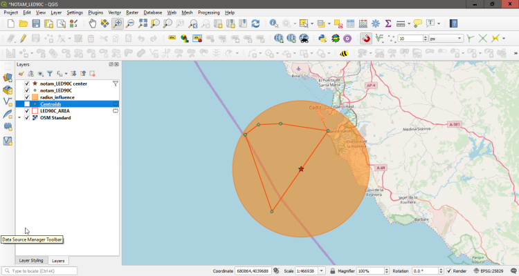
So maybe you know what the radius of influence is and sometimes you simply have no way to perform the calculations, I will go through a process using QGIS which may prove useful or at least provide some sort of idea of what to do and will let you also know what is happening in the backend of your NOTAM system as the process is fairly similar.
I will re-do the example using the same NOTAM above from Spain which I was not happy with the radius
First I will write a CSV file with the coordinates from AIP Spain for the area
id,lat,lon
1,36 27 20 N,006 32 54 W
2,36 29 00 N,006 30 00 W
3,36 29 04 N,006 25 11 W
4,36 27 35 N,006 14 55 W
5,36 13 38 N,006 27 34 W
6,36 27 20 N,006 32 54 W
Load the coordinates into QGIS

Create a temporary polygon with the area in EPSG 4326 as we use WGS84

Calculate using processing module the minimum enclosing circle (MEC)

Get the centroid for the MEC and round the values to only degrees and minutes as per NOTAM item Q


Calculate the distance in NM from the adjusted center (03623N00624W) to each of the original vertex and round up to the next integer using a distance matrix


From the image you can see that 18126 m is approximately 9.79NM which will be rounded to 10NM
Final coordinates and radius 03623N00624W010 which provide a much smaller area with less waste and a much better algorithm


Of course the above process can be and should be automated for use in an AIM NOTAM unit maybe some crowdfunding to deliver a web based system in the future.
On a final note once you round the radius to degrees and minutes the radius may need to be larger to accommodate for the less precise coordinates, it’s not so easy as just truncating and putting in item Q the coordinates.
See the example below, if the area is PJE within 1NM centred on 453029N0101531E just putting 4530N01016E001 in Qline (blue) will not provide coverage of the area, in this case you need to specify 4530N01016E002. So think a little about if the area is really covered or not

P.S. Each time you send a NOTAM without complete item Q including lat, lon and radius it probably goes to a NOTAM QUEU for manual processing by another NOF, you are just sending the problem further along the line.
So what do you think? Are you ready to level up and stop sending incomplete NOTAMs? Please try to send the correct radius of influence


2 Comments
Paul Tanui · November 27, 2019 at 1:15 am
New NOTAM need to address the issue of radius of influence, it will assist in reducing the number and improve the relevancy of information in a timely manner.
antoniolocandro · November 30, 2019 at 10:09 am
radius of influence is already an ICAO standard, unfortunately its not used adequately by many NOF around the world leading to implementations where NOTAM can’t be filtered out or shown geographically in a correct way.