About a month ago I made a post on Linkedin stating what my plans are for this 2023 for bringing an opensource aeronautical charting solution which would be available to any organization, business consultant or person to download and use. In this blog post I want to expand on my line of thought with the hope of bringing funding organizations that are able to jumpstart the initial development required to make it a reality.

One of the main complaints about aeronautical cartography that I have heard during my career working within air navigation service providers (ANSP) and in the private sector is about the quality of the aeronautical charting, at the end the main issue is how expensive the solutions out there from commercial off the shelf (COTS) providers geared specifically for our sector are. I can definitely relate to this personally for my business I am not able to afford a solution based on tens of thousands and honestly I can achieve very similar or even better results with my own tailored solution.
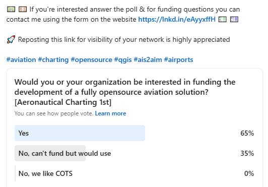
Not surprisingly the poll within the same post gave a clear idea of the sentiment of people towards the question if they would be interested in an opensource aviation solution. Even though some are not able to provide funds the overall response was positive although I need to state that just 26 persons from my network responded which is quite low but in most of these networks there are a lot of lurkers that will not or do not want to interact for several reasons
Before going into what we want to bring to the aeronautical charting community, I just want to make a brief exposition of what I believe are the three scenarios currently in place for making aeronautical charts.
Manual Solution using Computer Aided Design (CAD) or Geographic Information Systems (GIS)
For the most part, countries or organizations be it private or of other nature that are not able to afford an completely dedicated solution or those ANSP that haven’t yet transitioned into a fully automated digital production environment rely on the use of CAD or GIS tools where the aeronautical cartographer would need to create every chart without the aid of automation directly provided by their choice of software. This type of production does not really have too much thought into having a database or how the different elements would interact. At this level depending on your skills you may be able to get some spreadsheets to help out or if within the cartographers skill set they have knowledge of programming languages they might script some sort of solution. There is a lot of manual work involved trying to keep the charts and the aeronautical information publication (AIP) in sync with each other, mostly the charting unit is separated from the publication one and reconciliation between both unfortunately is done through user complains when they detect discrepancies.
This type of approach works well when you don’t have too much to update or often, normally for smaller countries with very few airports. However, these same countries probably do not have expertise in house to perform the job as having a dedicated staff for very low amount of work is probably not cost effective. Besides the salary, we need to factor in the cost of hardware, software and training to have a better idea of the global cost of ownership. These small countries will outsource their work to third party providers or may just do updates by staff that is not full time aeronautical cartographers, probably they would benefit more from outsourcing and just keeping basic proficiency to check the outsourced work for compliance with ICAO provisions.
Most, will choose the software industry leaders for their preferred platform which is usually the one they learned either at University or that is commonly used within their countries for engineering or topographic work. Even though opensource solutions like QGIS or LibreCAD may be able to help out most of the time they are not sought due to two reasons:
- Lack of exposure to opensource alternatives
- IT departments usually frown unjustly upon non COTS solutions claiming security concerns or lack of maintenance and support


Semi-automatic Solution using Commercial of the Shelf (COTS)
When the volume of information for a country or Organization becomes unmanageable to be handled through manual means this is when the first approach comes to buy a solution that is geared specifically for aviation. Normally solutions of this kind are very few and vendors are tied with their other offerings for the whole Unicorn (software that you push a button and every is done). Yes, you are able probably to buy some of these solutions and make your life at the office easier but for smaller ANSP and business this type of software starts to be prohibitive and thus they look into alternatives, for the most part this alternative is to create their own bespoke solution by hiring either a consultant to work for a few months developing some sort of scripts to automate stuff or their in house main aeronautical cartographer has enough skills to pull it by themselves.
Solutions you buy on the market require to buy anyway the main base license which you may have from the manual process as an additional cost. Most software are moving to a recurrent monthly or yearly subscription based model which means that if you stop paying you stop getting access to using the software. Long gone are the days of perpetual licenses. Usually this type of solutions work best for medium size organizations that do not do crazy amounts of amendments or changes to charts on each charting production cycle according to the Aeronautical Information Regulation And Control (AIRAC) cadence of every 28 days.
Definitely if you are larger organization that has a lot of airports you will not be able to get away for long with this type of solution and you need to move into a more automated solution
Automated Solution with direct Aeronautical Information Management (AIM) connection or created from datasets
The utopia of all solutions is the one where we are sold that by buying it all of our problems will go away. This software is the most expensive one as you are not able to use it standalone since it requires the connection to the main database to be able to query the information, extracting the relevant pieces required, transforming it into what we want to show as an aeronautical chart and loading it on the software main map viewer to produce a layout. This extract-transform-load (ETL) function depends on the database being complete and has all of the settings automatically applied. Color specifications, symbology, text symbols, size, scales are all done from either predefined rules written in some sort of configuration file or through the use of templates. Operators for this type of system ironically instead of being less technical savvy due the amount of automation involved is actually the opposite if you want to deviate from any predefined recipe. In essence as long as you accept all general templates and do not intend to customized anything specially if the customization is outside of the project scope or worst required post the end of support and maintenance.
Reality is that if you have an aeronautical database you are able to create your aeronautical charts either through direct connection to the database or from datasets which are exported out like an AIXM export for example. Direct connections are usually never really a direct one since you will not want to have the risk of corrupting the main database, usually a replica is created by the charting system by copying the feature from the main one into a development or charting database synchronizing the changes as needed. The use of datasets would provide the same way out as a replica database, you can get an export of the aeronautical features from the main database without actually accessing it which is good for security in terms of corruption of the database and you can pass these datasets even outside of your organization to authorized third party aeronautical charting service providers since you are no longer bound to a direct access to the main server.
One key thing to remember is that most fully automated solutions are built on top or as add-ons of a base CAD or GIS, which means you will require to have the subscription up to date for both the base and the custom solution built on top and if the aeronautical charting provider doesn’t update quickly enough then you may en up using very old unsupported CAD/GIS versions. Recently the world de-facto COTS GIS leader is experiencing some backlash as the new solution they offer is not 100% a 1:1 solution with the old one meaning there is a lot of training required to do the change which may be a good time to explore other options.
Opensource Aviation Solution for Aeronautical Charting
Now that there is an understanding on what ways we can produce aeronautical charts I want to go into what I intend to bring forward to the aviation community. It doesn’t matter if you are a small or large organization at the end of the day we all need to comply with the International Civil Aviation Organization (ICAO) Standards and Recommended Practices (SARPs) and one of the things we are required to be compliant with is the Aeronautical Charting Service as per Annex 4. Of course there are other documentation like Annex 15, Annex 14 and associated guidance material.
I still think there is a place for COTS and I am not advocating to get rid of it or against them, however I do want to present an alternative model which is open in nature and let users decide which one they will use based not only due to price but also considering functionality, openness, interoperability and software lock down.
Funding is required to get the initial development of the charting solution and this is why I am trying to get organizations to pitch in financially, we still have not decided on what the funding model will be but just take into considerations how much one single license of the base software costs and how much you need to add on for the actual aeronautical magic plus the recurring fees and you can start to see there may be a benefit there somewhere not only for the big players but in a sense democratizing and leveling the playing field for all actors worldwide. Instead of being bounded or limited to just having one or two aeronautical cartographers due to licensing you can invest that money into having more cartographers, or more training, even fund new features that were originally not envisioned.
For those that don’t know me, I am an Aeronautical Cartographer and Instrument Flight Procedure Designer (PANS OPS) working in aviation since 2008 and since 2019 which is when I went and created my own business. I have made all of my charts and procedure designs directly with open-source software, primarily QGIS. However, we used QGIS way before that since 2014 at my previous job together with the very robust and the main “competitor” of Oracle which is POSTGRESQL together with the spatial extension Postgis.

The first question you may be asking is can aeronautical charts be made with QGIS? The answer is yes! Actually I am in the middle of creating charts for a complete Aeronautical Information Publication (AIP) migration and have created specific training using QGIS for Managed-AIS. All of the Instrument Flight Procedure (IFPD) charts I have made since 2019 have been made using it and I have a small repository for some symbology at my github account , you can even search within this same blog for previous posts on making aeronautical charts.

So creating charts from QGIS is a proven method, I am sure many Air Navigation Service Providers (ANSP) around the globe use QGIS in their production environment in one way or the other even in conjuction with Postgresql/Postgis. For an odd reason they don’t market this like when countries buy COTS. You see posts everywhere when a country buys a charting solution but until now I have seen absolutely no statement from ANSP saying we went the open way! Maybe is because they think using opensource means you don’t have funds to buy COTS but actually many Governments, towns and business around the globe use opensource not because of cost (although that is certainly one of the reasons) but because it actually has functionality that is better than what their COTS counterparts may have.
Besides the question that comes with can you make charts the next question that comes to mind is what about the risk of using opensource? This is because we don’t want to invest time and money into something that will not work. That is absolutely a fair question and one that you should also be asking COTS? Are you sure that COTS you are buying is actually supported by a company that is able to handle sickness, developers moving or even death? With opensource all of this can happen but since the code is open and accesible anyone can continue building on top of it or fork it to their desires. This is why we are bringing Oslandia into the equation.
There is a misconception that opensource is unsupported and in the wild west but the reality is that it is a mature ecosystem. Many companies provide support and maintenance contracts for many of the opensource solutions we mainly use in the aviation sector, go and search for them as I do not want to favor one over another.
However for this project I am bringing Oslandia into the mix which is an innovative company specialized in GIS architecture. They provide services on Open Source software for which they are editors or recognized experts and in fact they are one of the largest contributors to the QGIS project. They will be the technical lead for the project guaranteeing that the solution is coded according to modern standards and in accordance to the latest development guidelines. Together with me as Product Owner and in charge of making sure we will be compliant with ICAO standards we think that we can provide an open solution that can benefit the aviation community.
Our main focus will be on developing a system that is capable of generating aeronautical charts in an automated way and extending it to perform analysis like Obstacle Limitation Surfaces and Take-Off Flight Path Area (TOFPA) in order to speed up the process. How far we reach depends on how much funds we are able to secure from our partners and the community and this is where I want to invite you in.
Opensource software is actually not free, someone has to fund for the initial development and we need to have maintenance to keep it always up to date and to incorporate new features plus squash quickly bugs if any. We do not have yet a model on how this will work, Oslandia does have experience with other similar initiative in the mining world (OpenLog)
Or we may do small crowdfunding campaings for some things or a mix model! We are still figuring this part out but for sure if we had funds we would have already a working prototype.
Speaking about prototypes we have plans on one of the following:
- Aeronautical Information Exchange Model (AIXM) viewer, because there is only one COTS and QGIS even though can render it for the most part it is yet not fully optimized for it
- ICAO Obstacle Type A chart for simple cases which are the typical ones consisting on a straight TOFPA

The opensource solution that we advocate starts as a semiautomated solution but in the future with enough funding and with a real push to interoperability and avoiding vendor lockdown we would like to take it further into a fully automated solution. We are meeting already this next Friday for the first time with a few other persons that have shown interest, more blog posts coming in the future but if your ANSP, consulting business or organization would like to be able to financially take part of this initiative do the numbers of what one single license will cost for COTS and how much you could fund this initiative to make it accesible not only to you but to the world. You can contact me on my website’s contact form
As the Apollo 11 lunar plaque had written “We came in peace for all mankind”, we approach this for the benefit of all!
Until the next post!


0 Comments