So I have been using QGIS on and off for as long as I can remember, maybe more than 13 years, at must admit that at the beginning when I started using it I wasn’t really impressed with the features against the leader vendor in my area which is ESRI. I use ESRI products pretty regularly at both my last job and my current one from the past 10 years. I got involved a little more in QGIS about 5 years ago trying to check it out because we wanted to migrate some of our aviation related stuff to a centralised database from where to make some other automated things like ENR tables and so forth, but at the end we just recently bought an AIM solution which has ESRI as the charting component.
Anyway, usually one of the things when I travel to provide instruction in the AIM domain or PANS OPS is the recurrent complain about people about how expensive the tools are to be able to make charts. QGIS has just made a huge new release QGIS 3 which is very powerful and feature rich, I can say in some areas it is now ahead of the paid stuff but can it be used for Aeronautical Charting? I remembered back in the day when I tried it was very difficult so I didn’t continue on that avenue.
One of the cool things of QGIS is that you can visualise AIXM 5.1 data out of the box, of course it lacks some of the core parts of a dedicated aviation viewer but it makes more than a decent job to see things reading from the cryptic XML/GML

Latvia AIXM data rendered in QGIS 3.4
So back to the idea on using QGIS, while adding AIXM data to check it doing the Data Validation and Verification process using an independent tool and because I am using my personal laptop so I don’t always have remote access to my work computer back at the office I started playing around with some data and checking how it would look after I have completed some proposed PBN procedure design to provide for validation of the conceptual design before flight inspection.
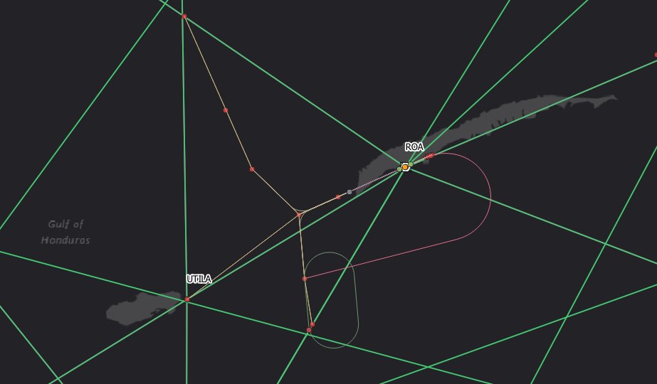
MHRO data, local data and AIXM data
So my head starting thinking, what if I could just recreate an aeronautical chart with QGIS, so that is where I am right now. Didn’t start with an ENR chart because that wouldn’t be a challenge, I could probably due that without too many problems rather quickly
So after a quick 1 hr of setting things up, I got a very promising looking chart. Everything marked in red in the marginal notes is data driven text, so it means I don’t have to type it and it comes directly from the attributes stores in the aeronautical features. Not bad for a free open source software. Doesn’t kill to have my chops for aeronautical charting either.

QGIS implementation

Current chart using ESRI
Will continue to work on this more until I get a result I like, but this actually looks very similar to what we are able to do with ESRI products and even a bit better as it was way easier to configure the data driven things.
Next steps will be to work on the labeling of the plan view
If you need some of the icons used for aeronautical features visit my github repository aeronautical_charting


8 Comments
Nick Gribble · April 10, 2020 at 4:29 am
Very impressive!
antoniolocandro · April 16, 2020 at 9:57 pm
Thanks! Although I may recall the ones you made were not so bad and actually used in the cockpit, great to hear from you
Tony Chambers · May 12, 2020 at 12:11 pm
I am also looking to make similar charts for heliports and helipads. Do you have a tutorial on how to make these in qgis?
antoniolocandro · May 14, 2020 at 5:01 pm
If you go to http://www.managed-ais.com/ and into Members > News Articles there are some videos you might watch. Let me know if you managed to find them
Daniel Savarese · July 29, 2020 at 12:02 am
Wow, Amazing Indeed!!!
Hi There, my name is Daniel, I am a GIS student from Montreal (QC), and I have recently discovered this WordPress page, after looking for possible Qgis applications in aviation and airport infrastructure management for days. It has been revolutionary so far and I would really like to learn more about it. Considering that I do have a solid GIS foundation but I am nonetheless lacking the aviation knowledge to complement both components, I would like to ask if you provide any training courses or if not, where would you suggest to start?
Many thanks in advance.
antoniolocandro · July 30, 2020 at 4:44 pm
Hi Daniel, thank you for your comments. Have you seen the following videos? https://www.mais-learning.com/blog there are a few more about charting with QGIS and with Managed-AIS we are preparing some awesome new stuff so keep posted! You can go to https://antoniolocandro.com/ and fill the contact form with your email so I can send you more information.
Daniel Savarese · August 3, 2020 at 1:49 am
Hey Antonio, Thank you so much for sharing this link, I hadn’t really found anything other than your blog, but I will make sure to go through all the webinars and videos featured on the page to develop more context understanding, hopefully it will be a good starting point!
Many thanks once again!
antoniolocandro · August 3, 2020 at 4:40 pm
My pleasure Daniel, if you got any further comments let me know!